COURSES
ERTH102-Physical Geology
This an introductory geology class for folks who are thinking about majoring in the sciences. Beginning in Spring 2008, I changed textbooks to try to reach a greater variety of student learners. The new textbook, Exploring Geology (Reynolds et al.), makes extensive use of concept-maps, 3-D images, and inquiry-based exercises to allow for more active learning than in traditional textbooks. In addition, I completely changed the lecture format, slides, and teaching strategies to try to better mirror the textbook. There is more active student participation in the classroom, and students are required to explain and sketch key concepts before moving on to other topics.
How are these concepts related to your life and where you live?
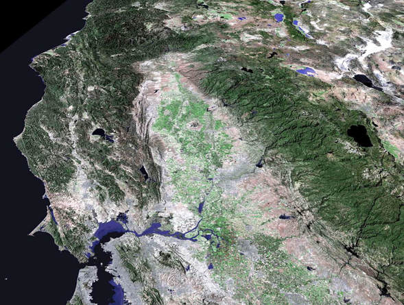
You will also be constantly reminded of how each topic covered in the class relates to Chico and/or the northern California region. We live in a very exciting time for the geosciences. Never before have the geosciences been more relevant to societal issues as they are today: energy, climate change, water resources, natural hazards, overpopulation to just name a few. At the beginning of class you will be given a photo of an aerial perspective of northern California. As we progress through the semester, you will report on how a particular subject covered in class is represented or impacts northern California.
Research in geoscience education indicates students are more engaged in learning when they understand how class content relates to their local surroundings. This project will try to reinforce that connection by having you create an original map and presentation materials documenting how your chosen subject matter relates to a satellite photo of the Sacramento Valley region (from W. Bowen).
How are these concepts related to your life and where you live?
You will also be constantly reminded of how each topic covered in the class relates to Chico and/or the northern California region. We live in a very exciting time for the geosciences. Never before have the geosciences been more relevant to societal issues as they are today: energy, climate change, water resources, natural hazards, overpopulation to just name a few. At the beginning of class you will be given a photo of an aerial perspective of northern California. As we progress through the semester, you will report on how a particular subject covered in class is represented or impacts northern California.
Research in geoscience education indicates students are more engaged in learning when they understand how class content relates to their local surroundings. This project will try to reinforce that connection by having you create an original map and presentation materials documenting how your chosen subject matter relates to a satellite photo of the Sacramento Valley region (from W. Bowen).
ERTH 455-Sedimentary Basin Analysis
“Sedimentary basin analysis” is a euphemism for “use everything in your tool kit to figure out a basin’s history”. Good luck! A multi-disciplinary approach is absolutely essential, and I hope you can practice a lot of different skills all in the name of deriving a plausible geologic history of a hole…a giant hole in time and space that is a basin. A basin subsides (part of the time), it is adjacent to a source area (some of the time), it gets buried (all of the time), and remains a relatively cohesive package of stratigraphic history that contains vast amounts of information regarding its subsidence history, the different source areas contributing sediment, and its diagenetic history.
The Purpose
If there ever was a hands-on course, this is it, I hope! Since most, if not all of you have survived the majority of Geology courses, it is time to put your accumulated brilliance to practical use. I will de-emphasize traditional lectures, and instead focus on activities that will let you practice what you have learned and will learn. Practice is the foundation for student-based learning, which puts more of the responsibility of learning on you. I believe in setting out goals for the course and to give you opportunities to practice during the semester in order for you to achieve those goals. With this, I hope you will have fun, learn from each other, yet build a sense of independence over time.
The Goals
Here are the goals that I have laid out. They are quite ambitious, yes, but think of all of the fun you will have spending quality time with each other!
By the end of the course:
1) You will be able to interpret an internally consistent depositional history for a given dataset of outcrops, sets of cores, logs and/or seismic. The interpretation will include reasonable assessments of sedimentary processes, applying appropriate modern analogs, and making predictions away from data-rich areas.
2) Using sequence stratigraphic principles, you will be able to evaluate how sediment supply and relative base-level changes controlled the development of the sedimentary succession.
3) Given a set of thin-sections, you will be able to interpret a provenance for the framework grains and simple diagenetic events/histories.
4) Given a dataset from an unfamiliar basin, you will be able to construct, analyze, and interpret subsidence history diagrams and assign plausible tectonic drivers.
5) Using a variety of datasets (either provided or from literature searches) for a given basin (such as provenance, paleocurrents, depositional environments, subsidence history, thermal history, stratigraphic packaging), you will be able to derive and present a reasonable tectonic setting and basin history.
ERTH 550-Fossil Fuels
Although I have unknowingly been preparing for this course since 2000, Fossil Fuels (ERTH 550) is a course developed from scratch in 2011. Needless to say, this course covers one of the most important drivers in human history-the need for plentiful, affordable energy. The answer to this quest for the past two centuries had led humankind through the Age of Fossil Fuels. To focus our efforts better during the semester, we concentrate on two energy sectors that heavily rely on fossil fuels: Transportation and Electricity. I have five main goals for the course, and everything we do will help you achieve these goals:
The Goals
1) U.S. Energy Outlook • By analyzing U.S. energy data and forecasts, you will understand what energy supplies and demands will look like for the next 30 years.
2) U.S. Energy Policy • You will evaluate U.S. energy policies and determine if they addressed the future needs defined in Goal 1.
3) Fill the Gap: Transportation (T), Electricity (E) • You will propose ways to “fill the gap” of future energy needs for: Transportation (oil) Electricity (coal and natural gas).
4) Environmental Risks of Filling the Gap • You will determine the environmental risks/hazards associated with your plan to “fill the gap”.
5) You will synthesize and defend an argument based on your research: (T) domestic oil & (E) coal vs. (T) imports & (E) U.S. natural gas
The Group Project
In order to reach the last goal (#5), you will conduct research on a specific energy theme for an assigned region. You will become a theme expert for your region, but you will be teamed up with others that are researching your theme but for a different region. In doing this, you will form “theme teams”, and your theme team will become theme experts for all of the regions. The themes include: petroleum systems (includes coal and natural gas), resource size, environmental risks/CO2 emissions, and resource-to-market feasibility. At the halfway point of the semester, you will turn in a report on your theme/region.
As you work towards the end of the semester, you will be split into new teams, and you will use your previous research to argue for a particular energy policy: e.g. pro-domestic oil and coal vs. pro-imports and natural gas. My goals for this project are for you to research a contemporary energy issue facing the country, to understand types of data available to the public, to synthesize and defend an argument, and to develop writing and speaking skills.
ERTH 580-Geologic Evolution of North America
This course is intended as a capstone course for graduating seniors in the Geology major. It is intended as a means for students to apply the knowledge and skills learned during required courses in the major to addressing the regional geology of North America. The objectives are two-fold:
1) to gain a general understanding of how North America (not just the Cordilleran) was pieced together beginning with the Late Proterozoic rifting of Rodinia all the way through the present-day tectonic setting
2) to focus on specific topics from particular phases in history through student-led reports and group discussions.
We focus on both major orogenies (active margins) where geologic histories are preserved as remnant chunks of former geologic entities that are juxtaposed, as well as major periods of passive margin basin development where the relatively uninterrupted basin fill records the evolution of a region. This course will examine specific articles which illustrate various lines of stratigraphic, structural, petrographic, paleontologic, geochemical, and geochronologic evidence which define the extent and duration of the orogenies discussed during the semester.
ERTH 630-Geotectonic Development of California
PART I. Tectonic development of California lecture
Lectures include: Basin and Range province; Cascade/Modoc Plateau; Sierra Nevada; Great Valley; Klamath Mountains; Northern Calif. Coast Ranges; San Andreas Fault system; Peninsular Ranges; Coastal/offshore California.
Part I of the course will also occur in parallel with weekly assignments on various provinces in California. The Professional Geology (PG) exam includes a California Specific Exam (CSE) that tests knowledge of California geology. The main objective for these weekly assignments is to help prepare for the CSE using some of the study sheets provided by the State. Instead of just trying to memorize faults, formations, place names, etc., these assignments will hopefully provide a spatial and temporal framework to organize the information that is expected prior to taking the CSE. For each province in California, students provide a virtual study guide using the scientific literature, Google Earth, USGS website, and any other pre-approved sources. The final product for each province will be a collection of organized Google Earth items (Placemarks, Paths, Polygons, Image Overlays) that summarize research of assigned geologic features.
PART II. Discussion of topics in Active Tectonics
Part II of the course will occur in conjunction with working on a specific topic having to do with active tectonics and surface morphology, with possible implications for: earthquake hazards, flooding, slope stability, coastal processes, groundwater, Earth resources (oil, gas, minerals, etc.), biologic resources, etc. A presentation of the project results will occur before the semester ends. The objective is to gain experience in using modern landforms to demonstrate active deformation or recent tectonically-induced events. The format of the project is flexible depending on the project. Ideally, the area and scope of the project overlaps with a part of a current senior or graduate project. Students use methods learned in this class to document active tectonics is occurring. This may include any of the following methods: geomorphic indices, river drainage indices, river or marine terrace indicators, drainage density, wind/water gaps, just to name a few. Most of this data can be derived from Google Earth but other forms of data can be used as well.
Topics covered in Part II: Chap. 1 Intro to Active Tectonics; Chap. 2 Landforms, Tectonic Geomorphology, Chronology; Chap. 4 Geomorphic Indices of Active Tectonics; Chap. 5 Active Tectonics and Rivers; Chap. 6 Active Tectonics and Coastlines
